
 |
 |
|
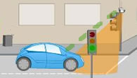
| RI Nodes can attach to exisiting infrastructure or be placed on lightweight poles | Simulated software updates as user travels from one RI Node to the next |
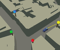
As the name suggests, Route Identification Nodes will be the main system for plotting directions and sending vehicles information. Drivers will input their destinations into a small, onboard computer. This information will be sent to the nearest RI Node, which will process the data and begin route planning. Using the information received from the vehicle the RI Node will send the vehicle directions, via radio waves, towards the next RI Node, and these software updates will continue at each successive RI Node along the route until the driver is at his or her destination. At any point during the trip, the driver will be able to change his or her destination. The RI Nodes will then redirect the vehicle to another route.
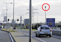
RI Nodes will be evenly dispersed every five blocks in cities and at every exit on the highway. The RI Nodes will be extremely subtle. In the city, Nodes will be placed on top of traffic lights, and on highways the nodes can be placed on existing infrastructure such as signs, and streetlights.
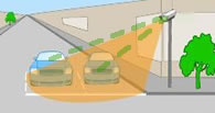
RI Nodes will be an enormous benefit because they will provide vital information that will allow vehicles to run autonomously. Even for those who do not use the autonomous feature, RI Nodes will provide drivers with information about weather conditions, traffic information, and suggested "best routes".
 |
| Route Identification Nodes receive destination and vehicle spec info from cars and deliver a route plan to the next RI Node. _ |
 |